CASE STUDY
Currently, unmanned aerial vehicles (UAVs) have played a significant role in replacing traditional ground surveys for terrain surface mapping. UAV surveys are faster and can access difficult or hazardous areas that may pose risks for ground-based surveys. Moreover, UAV surveys yield highly accurate results comparable to ground surveys.
Most UAV-based terrain surface surveys utilize aerial photogrammetry due to its cost-effectiveness and high accuracy, comparable to traditional ground surveys. However, there has been an increasing use of Light Detection and Ranging (LiDAR) technology for terrain mapping. LiDAR provides comparable accuracy and can penetrate vegetation-covered areas to map the underlying ground surface. Additionally, LiDAR surveys can be conducted at any time of day, including nighttime, which overcomes certain limitations of aerial photogrammetry. This is particularly beneficial for surveying coastal areas where low tide occurs at night.
LiDAR (Light Detection and Ranging) is a technology that emits pulsed laser signals toward a surface or environment and measures the reflected signals to calculate the distance between the sensor and the surface. By collecting distance and position data for each scanned point, LiDAR devices generate three-dimensional maps for further analysis or applications. Implementing UAV-mounted LiDAR for terrain surveys in this study enhances survey efficiency and mitigates the limitations associated with aerial photogrammetry, as previously mentioned.
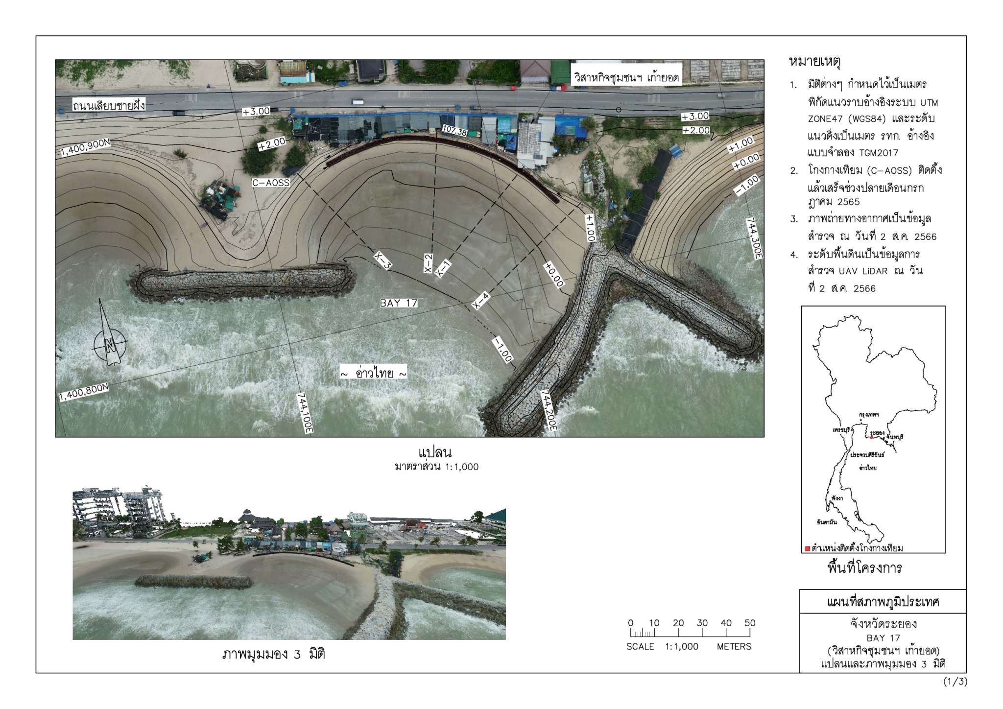
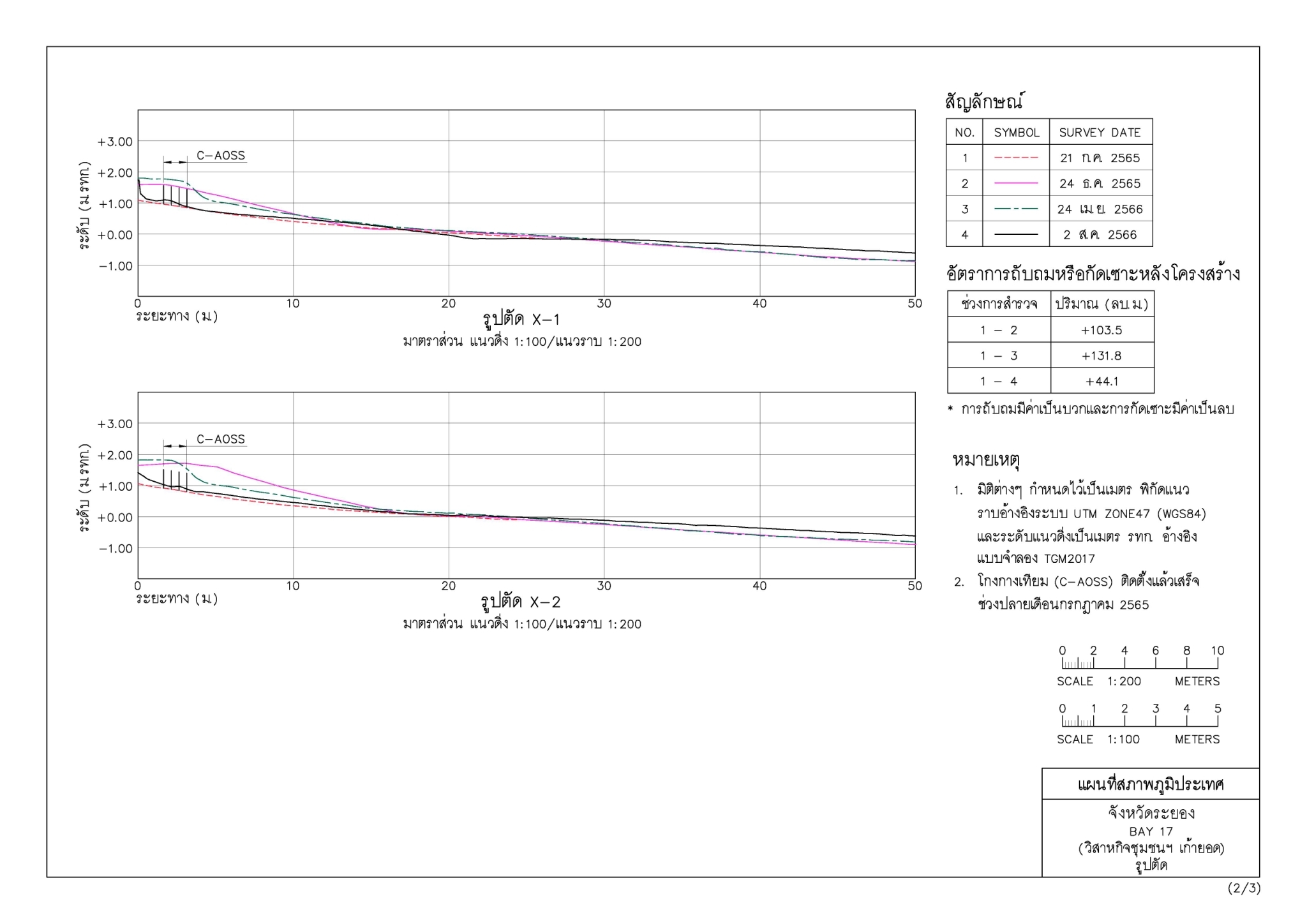
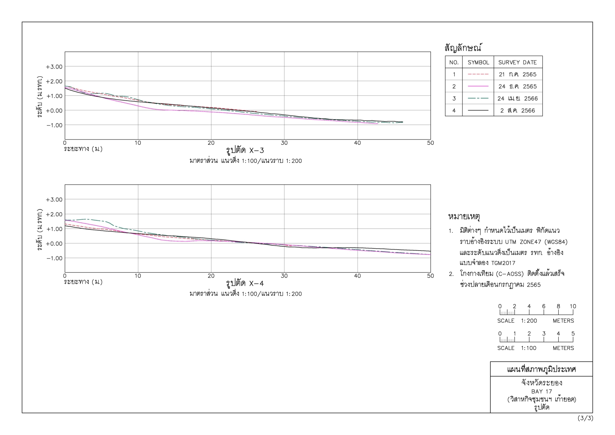
A case study evaluating the effectiveness of artificial mangrove structures using UAV-LiDAR techniques revealed that these structures help reduce wave energy and mitigate coastal erosion. This conclusion was drawn from the accumulation of sediment behind the protective barriers, demonstrating their effectiveness in stabilizing the shoreline.
Most UAV-based terrain surface surveys utilize aerial photogrammetry due to its cost-effectiveness and high accuracy, comparable to traditional ground surveys. However, there has been an increasing use of Light Detection and Ranging (LiDAR) technology for terrain mapping. LiDAR provides comparable accuracy and can penetrate vegetation-covered areas to map the underlying ground surface. Additionally, LiDAR surveys can be conducted at any time of day, including nighttime, which overcomes certain limitations of aerial photogrammetry. This is particularly beneficial for surveying coastal areas where low tide occurs at night.
LiDAR (Light Detection and Ranging) is a technology that emits pulsed laser signals toward a surface or environment and measures the reflected signals to calculate the distance between the sensor and the surface. By collecting distance and position data for each scanned point, LiDAR devices generate three-dimensional maps for further analysis or applications. Implementing UAV-mounted LiDAR for terrain surveys in this study enhances survey efficiency and mitigates the limitations associated with aerial photogrammetry, as previously mentioned.
A case study evaluating the effectiveness of artificial mangrove structures using UAV-LiDAR techniques revealed that these structures help reduce wave energy and mitigate coastal erosion. This conclusion was drawn from the accumulation of sediment behind the protective barriers, demonstrating their effectiveness in stabilizing the shoreline.


Powered by
MakeWebEasy.com